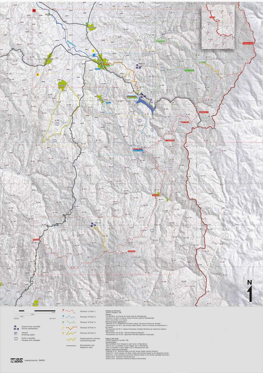
At the Berovo Tourist Information Center you can get a free map with 5 hiking trails in the surroundings. The tourist office is at the top floor of the big white building near 11th Oktomvri street, a bit out of the center of Berovo (see N41.70547 E22.85223).
A description of these trails can also be found on the website of Hotel Manastir in Berovo (http://www.hotelmanastir.com.mk/). I did not do any of these trails, and I don’t know if they are marked well. You probably best hire a local guide!
The descriptions of the trails are:
Trail 1
Transversal trail which bands the most southern and the most northern part of the malesevska area. It stretches from Prevedena 1200 till the top Kadiica 1932 in total length of 45 kilometers climbing on altitude variation of 730 meters above sea level with oscillation of maximum 800 meters altitude above sea level on minimum 5 kilometers. Time – taken to pass the trail is 12 hours. Because of the length and the transversal character of the trail it is recommended to hire local tourist guides. The places for pause are in village Dvoriste sheepfold near Karaula Divna, motel near dethrone of Klepalska Reka, in the vicinity at Ravna Reka.
Prevedena (1200) alternative clamber of Palazija (part of Strumica)/ clamber till the top Ograzden (1746), variation of (860), 3-4 hours dismount to village Dvoriste (920) altitude variation of (860) dismount in 2 hours and 30 minutes. Clamber to top Babin Cukar (1406) variation (480) time – taken to pass 1.5 – 2 hours. Dismount 200 meters till Zamanicka Reka and climbing till Karaula Divina (1366) blunt dismount till Klepalska Reka and gradually clamber through m. v Dabavec, Cemerikov Preslap, Ravna Reka, Pobien Kamen, Cengino Kale (Fortress) – the most eastern spot of R.Macedonia 1748 m altitude above sea level, where from along the border line with R. Bulgaria propels with insignificant oscillation till the highest top Kadiica with 1932 m altitude above sea level.
Trail 2
Streches from Berovsko Ezero (1000) via Babin Cukar (1403) and village Ratevo (920) till the final destination Berovo (840).
Total length is 21.5 kilometers.
Time – taken to pass the trail is 6 – 7 hours.
The trail goes through more sheepfolds and is recommended accompaniment of local tourist guides.
Places for pause – Berovsko Ezero, Sheepfold near Babin Cukar, village Ratevo and Berovo.
The highest altitude variation of clamber is 400m altitude above sea level with insignificant oscillations and gradually climbing. At the beginning there is tourist settlement Berovsko Ezero with primary clamber of 100 meters till top Saban and goes through plateaus vivid forest areas of white pine which gradually changes in to beech woods via Babin Cukar and returns through the extensive pastures and the rear forest on pine in the village Ratevo till Berovo.
Trail 3
Berovsko Ezero via Pecov Cukar 1490, Breza 1443, Ravna Reka, Parkac till Berovo. Total length of the trail is 25,6 kilometers. Time – taken to pass is 7 hours. The trail goes through more sheepfolds and is recommended accompaniment of local tourist guides. Place for pause – Berovsko Ezero, sheepfold Breza, Ravna Reka and Berovo. The trail goes through beech and pine woods.
Trail 4
The hiking trail from Berovo (Juovec) – Tourist settlement Ablanica to Berovo Lake is realized in the frame of the project “Along grandfather trails”. The trail is 6 km long and passes by meadow and forest area below the centennial pine, beech and oak trees. You can find a lot of herbs and wild fruits along the trail. There are two places for rest. The trail is suitable for mountain biking.
Trail 5
This is the trail which passed Damjan Gruev running awey from the Turkish soldiers (asker) in 1906. Petlec is the place where he was killed i.e. committed suicide. The trail is long 15 kilometers. Time – taken to pass is 5 hours. The trail is located from village Rusinovo 830 via Petlec 1250 lower of the top which is 1350 and returns back in village Rusinovo.
