
The Kale Parembole Fortress are the remains of a castle that can be found along the Via Egnatia hiking trail that is described in the book “Via Egnatia on foot” by Marietta van Attekum and Holder de Bruijn (https://viaegnatiafoundation.eu/). The Via Egnatia was a major Roman road built in the 2nd century BC that connected the Adriatic Sea with Byzantium (modern Istanbul), linking the western and eastern parts of the Roman Empire across the Balkans.
However, we were not on foot but by car, on our way from our previous accommodation in Demir Kapija to Ohrid.
The ruins of the Parembole Castle are found between the villages Kazani (Kazhani) and Dolenci, somewhere halfway between Resen and Bitola.
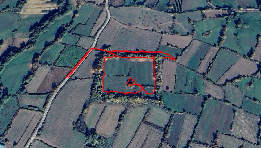
We parked the car alongside the asphalted road between the villages to visit the Parembole Fortress.
The book “Via Egnatia on foot” describes the Kale Parembole as follows:
“A quadrangle about the size of two soccer fields, surrounded by bushes, covering the 2 m high remains of old walls and four round towers at the corners. Brought to light in 1928, the archaeologists have established this place to be a Castrum Romanum, that is to say a Roman army camp, a mansio. The camp guarded the important Djavato pass. At the eastern site there is an opening, where a 3.30 m wide gate used to be. The place was identified as Castra Parembole, mentioned in some of the old itineraries.
East of the fortress the remains have been found of a Roman civil settlement.
There is some dispute among archaeologists, but it is believed by some of them that Nicea and Parembole are in fact the same place: a large station on the Via Egnatia, just before the city of Heraclea (Bitola).
Throughout this region, in and around the villages of the plain and at the foot of Mount Pelister, Roman remains have been found. Farmers uncovered Roman earthenware while they were ploughing and old walls and foundations have been brought to light during road construction.
Remains of a Roman road surface have also been found near the village of Bratin Dol, but it is not sure that this belong to Via Egnatia. It seems that there have been more Roman roads here connecting the villages. The exact course of the Via Egnatia has not been precisely established yet”.
The Macedonian Encyclopedia says the following about the site:
“NICAE, DOLENCI, BITOL – late antique castrum, south of Dolenci, on the Egnatian road, 18 km west of Heraclea Lyncestida. The fortification frame of the fortress (Castrum, Parembole), with dimensions of 125 x 122 m, with 10 horseshoe-shaped and 4 round towers, was formed in the early 4th century AD. Part of a large basilica with mosaic floors was excavated in the perimeter. Less than a kilometer east, at the Suvi Livadi site, a second basilica (6th century) was excavated and 1.5 km east of the castrum (at the Ramenska Tumba site) a third basilica was found, both with mosaic floors and with several examples of stone architectural elements from the windows and altar partitions. Originally planned and designed as a military facility (to control the Egnatian Way), in late antiquity the Nicaea castrum grew into a civilian city within the same walls. Sources: I. Mikulčić, Ancient Cities in Macedonia, Skopje, 1999, 330–331; V. Lilčić, The Macedonian Stone for Gods, Christians and Life After Life, Ⅱ, Skopje , 2002, 758–765, 770–773)”
Pleiades lists the site as a late-antique fort with names Castra (1st century BC–3rd century AD) and Parembole (4th–7th century AD)

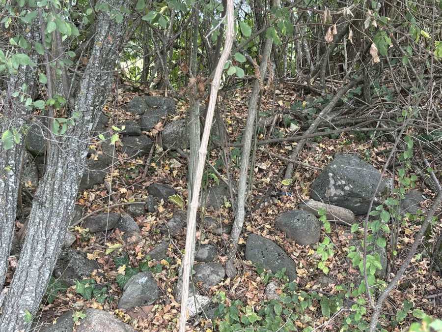
The remains of the walls of the Kale (Fortress) Parembole were completely overgrown in the summer of 2025 and we saw no clear remains of towers. In the middle of the fortress there are the remains of a wall or tower. Not much to see from the ground, the most interesting picture if comes from Google Earth where you can clearly see the outline of the fortress (see above).


We took the car and continued less than 1 km to the Muslim village Dolenci, where we parked. We followed the description of the “Via Egnatia on foot” book to find the remains of the Early Christian basilica Ramenska Tumba. It’s about 3.5 flat kilometers to the basilica and back
According to the book there should be the remains of a 8 m wide road along the trial, but we could not find them.
The ruins of the early Christian basilica Ramenska Tumba were completely overgrown with thorny bushes and the site was basically impenetrable.
According to the book there are also remains of an old road here, which according to the locals is the Via Egnatia.
Wikipedia says the following about the archaeological site Ramenska Tumba between the villages of Dolceni and Ramna: “It is a basilica from the early Christian period. It is located 2 km southwest of the village Ramna, in Caparsko Pole, where an early Christian basilica was discovered during protective archaeological excavations in 1966. The basilica is three-nave, with a narthex and two annexes on the southern and one on the northern side. The floor was paved with bricks“.

The two sites Kale Parembole and Ramenska Tumba were not very interesting to visit, because they were so overgrown that there was little to see. It is usually more fun trying to find these sites than actually finding them!
Other (supposed) remains of the Via Egnatia that I know of are in the village Radozda at Lake Ohrid and Capari, which is a village just south of the two archeological sites described here.
You can view and download the GPS tracks for these two sites here:
https://www.wikiloc.com/hiking-trails/kale-parembole-fortress-239563955
https://www.wikiloc.com/hiking-trails/ramenska-tumba-early-christian-basilica-239570563

