
WARNING: parts of his hike were very badly overgrown in September 2024. The bushes, often with thorns, made it almost impossible to get through at some points. I advise not to do the version of this hike that we did.
The hike was about 12 km with 850 m ascent
We tried the follow the route posted on Wikiloc, walked in Februari 2024, probably when there was less vegetation than in September, although the author already mentioned that the unmarked hiking trail was overgrown: https://www.wikiloc.com/hiking-trails/s-pusta-reka-krstovi-vrv-kozjak-vrv-rebor-vrv-mala-musica-161728788#

The hike starts in the village Pusta Reka, which was half an hour drive from our base in Krushevo. The church of St Nikola in Pusta Reka was closed.
After about 2 km the bushes on the trail become almost impenetrable, for about 500 m. This is indicated in the GPS track with waypoints.
After that it becomes slightly less overgrown with impenetrable bushes, but they are replaced with fields of ferns that reached to our shoulders, making the ascent through these fields quite difficult. The grade of the ascent is 35-40% for this part, so pretty steep going up! We deviated a bit from the original GPS track here.

Almost near the peak with the crosses (named Krstovi), I noticed a trail with red/white marking, likely leading to Pusta Reka. This point is indicated with a waypoint. Indeed, another trail on Wikiloc crosses this point. This may be a better trail from Pusta Reka to Krstovi than the ascent we followed! See here for the likely better alternative trail by Sibel, whose hikes I would trust: https://www.wikiloc.com/hiking-trails/musica-planinarski-predizvik-12-vrvovi-65363569#
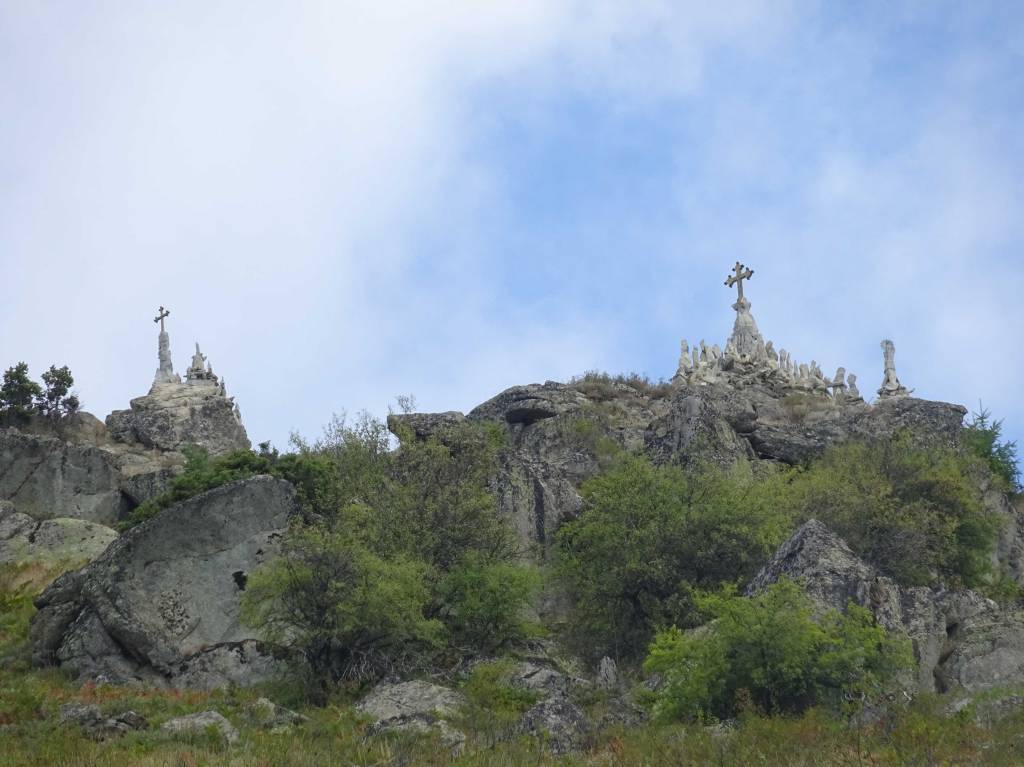
The peak with the crosses, Krstovi, is really very nice and picturesque and we had a good break here. See here for some extra info on this piece of art in the mountains: see https://zelenaberza.com.mk/simeon-stojkovski-chovekot-koj-so-svoi-racze-napravi-svetilishte-na-vrv-na-bushova-planina-2/
The next part of the hike was easy-going with a better trail and good views until the Mala Musica peak.
After the Mala Musica peak, the route went down, freestyle without a trail. Also here at some points the vegetation was so dense that we could not follow the original GPS track. We avoided the “open” fields and went a bit more through the forest where there were no thorny bushes.
This freestyle part continued maybe for 2.5 km from the Mala Musica top, after which you reach a real trail that leads to the village Gorno Divjaci. The point where we reached this trail is marked with a waypoint. So, the part between the Mala Musica peak and the waypoint “Trail” is not recommended!

From the village Gorno Divjaci it is about 2.5 km back to Pusta Reka, on a trail that was a bit difficult to find but later easy to follow.
Overall, we really disliked this hike because it was just too overgrown. There were also lots of flies, which did not help improving our mood. The hike gets 1 star out of 5.
Alternatives to reach the nice Krstovi peak are the trail from Sibel posted above, or start near Krushevo and prolong this hike to the Stara Musica Peak that we did a few days earlier: krushevo-cross-st-preobrazhenie-monastery-stara-musica-peak/
You can view and download the GPS track of this hike here: https://www.wikiloc.com/hiking-trails/pusta-reka-krstovi-gorno-divjaci-187918820

